A couple of weeks ago, I took a drive
out to El Malpais and hiked a new-to-me trail, The Narrows Rim Trail. It seems likely that this trail leads to an overlook opposite La
Ventana Arch, but I didn’t make it that far.
Driving down 117, I made a brief
stop at the Visitors Center (cell service but no wireless). I passed the Sandstone Bluffs Overlook (you should stop, if you’ve never
been). I paused at La Ventana but didn’t get out. Then, about 3 miles later, I pulled over to the left to the not terribly well-marked
picnic grounds (it’s just before things suddenly open up to the left).
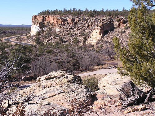
The route up to the bluff is surprisingly easy, given the altitude
gain. The trail has lots of cairns and alternates sandy and rocky. Following the rim in many places, you have spectacular views out over
the lavaflows to the west and to the mountains beyond. This area has many stunted ponderosas whose twisted trunks attest to the steady
winds.
There is an elaborate marker at 2 miles. I turned back around 3 miles and I’m guessing (from maps) that it is not 4 miles
to the end of the trail. I was probably close to the end, but afraid of staggering back under a full moon.
Not too much farther
south on 117, to the right, is the Lava Falls Trail. If you never have hiked on lava, this is a good place to get started with a 1 mile
loop. The “falls” themselves disappointed me, but I loved the scramble beyond them to a kind of amphitheater.
Of course, there is
also the Zuni-Acoma Trail, 7 1/2 miles across a narrow part of El Malpais. It’s truly wonderful. With more ponderosas, some quite large,
it is much greener than one expects (but, definitely not a summer hike). If you don’t have time for the full ZAT, you get to lava sooner
from the east end.
On my drive back, I left pavement near the Visitors Center at a turn I’ve never noticed before to discover a
BLM campground of about 10 sites widely separated (but virtually no visual separation). There’s a modern outhouse; probably tables and
grills, but I can’t seem to recall. This spot has a nice view of the cliffs but not the lava (I think). It’s a bit close to the road,
but I bet it’s quiet late at night. I’ll be back for an easy overnight close to home.
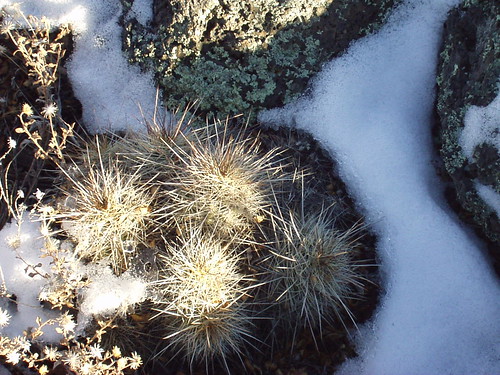
A few days later, when Albuquerque didn’t
get a storm that was teasing us, that storm passed right over this area. As did another a week or so later. Snow on lava is a very cool
thing to see. mjh
Photos (15 this year, 18 from a year ago).
Also 16 pictures from a ZAT hike 3 years ago (including 2 maps).Park Service’s El Malpais website (map as PDF).
Beautiful pictures! It sounds like a great area for hiking. I can’t wait until the summer.
Never hiked the trail, but if I remember correctly the southern trailhead is at a small campground. We once camped there while biking
from Durango to Palomas, Mex. We met a CDT through hiker there who must have had some pretty harrowing experiences coming north. And he
wasn’t even that far north. It had to do with water in the backcountry of NM. Most noticable was his inability to speak. He would
finally start to say something and then his voice would trail off. Too much time alone. He was young (in his early 20’s) and had
already done the AT and the PCT. This was his biggest challenge yet. His mother had made his tent. He had slept on the porch of the
Toaster Lady in Pie Town. He said he was sticking to the roads for a while.
Breathtaking photos
you got there. I just love hiking. I just need to get out of this flu first before putting my hiking shoes and hike like there’s no
tomorrow.
Tommy L. from Camping Tips
Great photos.
Edward P. Tryon – In answer to the question of why it happened, I offer
the modest proposal that our Universe is simply one of those things which happen from time to time.